Lesson developed by Rajni Bhargava (YHS Fulbright-Hays 2022)
- Lesson 2 Warli Folk Tale and
- lesson 3 Warli Lifestyle
Proficiency Level: Novice Mid/High
Time: 4X75 min
Objectives: Students will be able to:
- name main states and cities in India and their location on the map
- identify, name and describe in simple sentences the main physical features of India
- ask and answer questions about locations and landscape using the four directions and appropriate geography vocabulary
Language Targets: Students will be able to use:
- ask questions with क्या and कहाँ
- use simple postpositions: में, पर, के पास, से दूर
- review: use demonstrative pronouns: यह, वह > ये, वे
- use adjectives and noun-adjective agreement बड़ा,छोटा
- review: noun declination: singular/plural, masculine/feminine, oblique
- use oblique of demonstrative pronouns
- review: use copula sentence
- geography-related vocabulary
Performance Task: Students will keep a journal of exploration complete with maps, photos and notes for each of the features. Once they return, students present their explorations to elementary students. Elementary students are expected to learn from their materials about the geographic features of India.
- ROLE: Geographer
- AUDIENCE: primary school students
- PROFICIENCY: Novice High
- FORMAT: Writing: Students choose (photo journal, flipbook, etc.); Speaking: Students choose (Podcast, audio-recording with flipbook, etc.)
- TOPIC: Geographical features, locations and communities
- Special Language: list geographical features, locations and map directions
Geography Project: Instructions: You are a geographer who has been chosen to visit and document various geographic regions in India where people live. You will present to primary school students. You will be teaching your findings as part of their learning about the world. You must choose a region to explore and visit all the features (rivers, mountains, deserts, major bodies of water, valleys, plateaus, etc.) powerpoint: भारत
- Choose 3+ locations
- Describe what you ‘see’ there in the photos (3 from each region) and on the map
- Use the following language targets:
|
|
ASSIGNED GROUPS: You will be assessed based on the following rubric:
| Criteria | Explanation | 1 | 2 | 3 | 4 | 5 |
| Creativity | Elements in the information are woven together with insight and imagination grabbing the attention of the intended audience. | |||||
| Content | Three locations and their descriptions are included | |||||
| Facts | The information is accurate and verifiable. | |||||
| Written Work: | 15 sentences including geography-specific vocabulary and the target structures are used. | |||||
| Audio Work | The length is 1.00-1.30 minutes. Pronunciation is clear and comprehensible. | |||||
| Technical Aspects (bonus points) | Product reflects effective use of educational tools, use of fonts, visual materials and/or sound recording. |
Scoring Guide:
5 = The highest score possible; indicates a highly effective use of a component. Exemplary demonstration of effort and achievement throughout the video
4 = Accomplished use of component(s) is consistently demonstrated throughout the video
3 = Elements described may be present, but are inconsistently or haphazardly applied
2 = Effort is demonstrated towards incorporating the component(s) listed and described, but the desired results are not seen in the final product.
1 = Scores of 1 reflect the absence of the described elements.
Learning Episodes:
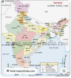
- Students are introduced by the teacher to the map of India and the geographical features of the country: भारत. The teacher introduces grammar.
- Students explore the map of India and directions भारत . They practice grammar structures. The teacher supports use of grammar targets on the board.
- In pairs, students choose 5 places on the map of India get ready to to tell three facts about that place; (a) the direction, (b) another place close by and (c) a famous landmark (they use के पास, से दूर, X उत्तर में है ). They share with the class and the rest of the students note down the facts, so that they are prepared to play a game afterwards.
- Students are given a blank map of India and in pairs students fill in the map of India with the names of states and capitals. Each student is assigned a name of a place, e.g. the capital, a state, a village, a town or a famous landmark in India. Students stand in a circle and play a game with a ball. Whoever gets the ball, the rest of the students need to tell three facts about that place the person is assigned to: (a) directions, (b) famous monument or close by place (c) state in India.
- Students are assigned to find out where their parents or anyone whom they know are from in India. Again they need to find out and write 5 facts about that place.
- Students are given a vocabulary list about the physical features of India. They are tasked to create 3 categories and enter them in a table.
- Students are introduced to the physical features on the map of India. भारत Physical Features Of India (Bharat Ka Bhautik Swarup)_IX ( 0.00-0.45) with the support of the vocabulary list.
Map of India: https://hindi.mapsofindia.com/geography/
