
PART TWO: GEO-REFERENCING MAPS AND HISTORICAL CARTOGRAPHIC SPACE
Week 5 – 9 (Tu 21 Feb)
On “Map Compilation”: Projections, Visual Variables, Cartographic Source Material
Monmonier, “Bearings Straight,” Rhumb Lines and Map Wars, 1-16
Monmonier “Visual Variables of Jacques Bertin,” Mapping it Out (1993!)
Monmonier, “Cartographic Sources and Map Compilation,” Mapping it Out (1993!)
Schmidt, Metro Maps
The True Size
10 (Th 23 Feb)
Exploring Historical Maps of the Arabian Gulf and Indian Ocean
![Jodocus Hondius [Public domain], via Wikimedia Commons](https://bpb-us-e1.wpmucdn.com/wp.nyu.edu/dist/7/5209/files/2017/01/Picture1-300x227.png)
Jodocus Hondius [Public domain], via Wikimedia Commons
Mastronunzio/EDai Prà,“Editing historical maps: comparative cartography using maps as tools,” e-Perimetron 11.4 (2016):183-195.
We will meet in the NYUAD Archives and Special Collections in the back of the library to see and to choose a few historical maps of the Gulf region to work with. We will use digital photography as a means of digitizing them and discuss questions of light, color, detail, medium. We will attempt to digitize some archival maps of the region, maps of the growth of Dubai, travel maps across the Empty Quarter.
One significant map we will be digitizing is the “Red Sea, or Arabic Gulph, chiefly from observations made by C. Niebuhr in the Years 1762 & 1763.” Compare our digitization of Niebuhr to this version, this digitized version of the book from Munich and this digitized version of the map from EECO.
Blog posting 3 : Choose one of the maps in the collection and write up a short blog post about it, including any detail photos that you have taken. The general folder containing the images we took during last class can be found here. In that post you should include the persistent URL of the object in NYUAD’s collections, any information you can find about the map maker as well as a description of the map.
Week 6 – 11 (Tu 28 Feb)
Exploring “Georeferenced” Digital Map Libraries
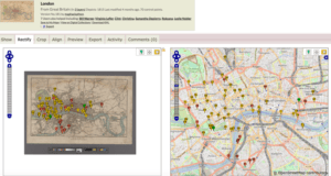
Download: please install the Google Earth plugin on your laptop. Make an account at mapwarper.net and maps.nypl.org/warper.
Objectives of today’s class: (1) introduce the idea of digital map library (different digital spaces where maps are stored, manipulated, archived, delivered, played with), (2) gain an understanding of descriptors (metadata) for maps and why they matter, (3) having an awareness of different degrees of openness of data and the benefits and challenges of each
This class will consist of a discussion of digital map libraries and have three hands on exercises to learn what can be done in such environments.
(1) EXERCISE 1: We will practice georeferencing using New York Public Library’s Map Warper on a 1720 map of the Yemeni/Omani coastline (from Maculla [Al Makullah] to Dofar [Dhofar]). That map can be also be found here and here for sale. First, we will have to locate the general area. Georeferencing? Georectification? Map warping?
A map of maps: British Library GeoReferencer
(2) EXERCISE 2: You will go to look at some other map library and report back on what they contain (both subjects and infrastructure). David Rumsey Historical Map Collection / Old Maps Online / Earthworks (Stanford)
Harvard Geospatial Library / Perry-Castañeda Library Map Collection
(3) EXERCISE 3: a hands-on with the NYU Spatial Data Repository.
12 (Th 2 Mar)
Digitizing Historical Maps, Introduction to Georeferencing in ArcGIS
Read: Presner et al, “The View From Above/Below” HyperCities
Clifford et al. “Georeferencing in QGIS” Programming Historian
Objectives: to work on geo-referencing and creating vector data using ArcGIS (room 303 of the library). NOTE CHANGE OF LOCATION
Explore: Take a look at these openly available maps of Abu Dhabi, or that include Abu Dhabi and the UAE (1), (2), (3), (4), (5), (6), (7), (8), (9), (10), (11), (12), (13), (14), (15), (16), (17), (18), (19), (20), (21), (22)
What do they represent? What kind of approximation of reality are they? What do they tell us about the way spaces are understood and constructed by map makers? Who do you think the map makers were? What kinds the ideological positions do their maps make?
You can find more maps at the Qatar Digital Library (search Abu Dhabi maps, UAE maps, Trucial Coast maps). Some are even available for download and reuse.
In class we are going to work with map #13 and georeference together it using ArcGIS. This map represents the geological expedition of two men in the 1930s in the UAE. We will learn how to extract vector data and overlay that onto the larger map of Abu Dhabi (c 1970) and its petroleum resources we digitized in the previous session. If there is time, we will work with the 1963 and 1981 maps of Dubai and you will georeference them on your own.
Context for today’s exercise provided by the USGS report “Geology of the Arabian Peninsula“: “Geological exploration was carried forward steadily, and by the fall of 1937 nine field parties were working in the concession. Surface mapping, seismograph studies, and structure drilling continued, and in 1939 a gravimeter–magnetometer survey was started in the coastal area. This same general level of activity continued until 1940 when work was gradually curtailed with the advent of World War II. When the war forced a general suspension of operations, Aramco geologists had mapped in detail some 50,000 square miles and had completed reconnaissance surveys over an additional 175,000 sq mi. They had penetrated into the northern portions of the Rub’ al Khali, southwest as far as Wadi ad Dawasir, west across the Tuwayq Mountains in several areas, and northwest to Wadi as Sirhan adjacent to the Jordan border. During this period oil was discovered at Abu Hadriyah in 1938 and Abqaiq in 1940, unsuccessful wildcats were drilled at Al ‘Alah in 1937 and Ma’qala’ in 1940, and a triangulation network was started to provide accurate control for the various surveys then under way.” (page D3)
Perry Castaneda library map of Saudi oil infrastructure.
Map of the locations mentioned in this passage (against oil fields listed in GeoNames). Dataset
Blog posting 4 – Please choose one of the Qatar Digital Library hand drawn maps, georeference it, and using ArcGIS create vector data from what the map represents, in your opinion. What distortions, or warpings, occurred? Make this data available for download from your blog, by creating a public data folder in your web hosting. Explain what metadata is important to include for the map and give any important commentary for understanding it as an archival object. We hope to publish this vector data to NYU’s Spatial Data Repository. You can work on this 14 March in class.
Week 7
13 (Tu 7 Mar) Soviet Maps of the UAE 1 – hands on (room 303 of the library)
Objectives: practice georeferencing, creation of vector data, metadata
Work with two maps representing travelers on the Arabian peninsula. Put your notes and considerations here.
We will explore Soviet made maps of the UAE in the 1970s like this one and compare them with OSM and Google maps.
Data Services GIS Day 2016
Carter, “Hyper Detailed Soviet Maps of Washington, DC”
Carter, “Rhetorical Lives of Cold War Maps” Mapping the Cold War, 1-26.
For understanding the Cyrillic alphabet on our maps, see this article.
See also John Davies detailed site.
14 (Th 9 Mar) Soviet Maps of the UAE 2 – hands on (room 303 of the library)
Blog posting 5 Soviet Maps: Choose one of the locations or areas that stood out to you in the UAE as it is depicted on the Soviet Maps. Do a little research into this domain. Are the 1970s maps “accurate?” Do they emphasize or de-emphasize certain features of the UAE? Does Carter’s argument about the “rhetorical lives” of the maps hold in this case? Can you comment on Carter’s point that cartography is situated in a “dynamic of revealing and concealing”? (3)? How? Why? How does the map you chose differ from map #21 above?
In between weeks 7 and 8, watch the #DHIB2017 hashtag on Twitter for news from the Digital Humanities Institute – Beirut. Make sure that you add your input on our collective project.
Spring Break!! 16-25 March