
PART ONE: MAPPING AND SPATIAL DATA VISUALIZATION
Week 1 – 1 (Tu 24 Jan)
What are the Spatial Humanities? What are the Digital Humanities?
Introduction to Spatial Humanities and Examples
- The instructor will draw upon these readings. It is not necessary to read them all. We will return to them over the semester.
- Bodenhamer, “Narrating Space and Place” DMSN 7-27.
Harris, “Deep Geography – Deep Mapping” DMSN 28-53.
Presner et al, “Thick Mapping in the Digital Humanities” HyperCities 15-21.
Presner/Shepard, “Mapping the Geospatial Turn” NCDH 201-212.
Jessop, “The Inhibition of Geographical Information in DH scholarship” LLC 23.1(2008): 39-50.
PC Mag on Mapping
Values of DH
Sample Map projects: Edmonton Pipelines, Mapping Dante, Year of the Riot, Harlem 1935, London Chatty Map, Slave Revolt in Jamaica, Going to the Show, Mapping the Lake District: A Literary GIS, Linguistic Landscapes of Beirut, Digital Karnak, NYT’s pick, Wandering Rocks, NoSweatShakespeare map, (LOTR, Life of Maya Angelou, Novel City Maps), Photogrammar.
Case studies including mapping: D_H (pp. 61-71).
Discussion: How might these mapping projects be said to be “deep” or “thick”? Where do the data come from?
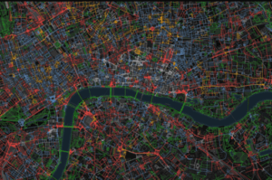
http://goodcitylife.org/chattymaps/
Week 2 – 3 (Tu 31 Jan)
Making a Map Across Disciplines: Historical and Contemporary Perspectives
- Prunel-Joyeux, “Do Maps Lie?” Artl@s 2.2(2013).
- Wrisley, “Spatial Humanities, An Agenda for Pre-Modern Research” Porphyra 22(2014).
Nowviskie, “How to Play With Maps” (2015). (password is course code minus hyphen, no space). - Horak, “Using Digital Maps to Investigate Cinema History,” Arclight Guidebook, 65-102.
Guldi, “What is the Spatial Turn?“.
Discussion: What kinds of different point-based maps based on cultural and humanities materials can you imagine in your field(s) of interest? What if you were to add more than points (polygons, different map bases)?
What is Participatory Mapping?
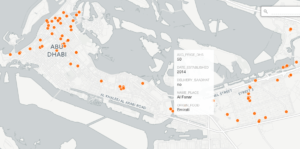
Introduction to the Food Cultures of Abu Dhabi Project, with an Intro to Carto
Get an academy plan here. Check out their map academy here.
Prepare: See these sample analyses from students from Fall 2016 in AHC-AD 139 (with their suggestions for this semester: (1) (2) (3) (4) and this sample map by average price. Notice areas of the city that are not represented in our data (Al Rowdah, Al Bateen, Al Maqta, MAZ, MBZ, Musaffah, Al Mushrif, Al Mina, Reem Island). Download the application Fulcrum onto your Android or iPhone. Download the text editor of your choice to your laptop: Atom, Sublime Text, NotePad ++.
Read:
- Warf, “Deep Mapping and Neogeography” DMSN 134-149
- Presner, “Mapping Events / Mapping Social Media” HyperCities
In-class Discussion: What are the benefits and drawbacks of “messy” and “coarsely granular” maps? How do the maps of the Foods Cultures of Abu Dhabi differ from this map made by NYUAD students of cheap eats?
Demonstration of how a web mapping can work.
Week 3 – 5 (Tu 7 Feb)
What is Text Mapping?
Last time, we explored the idea of using geolocation services for smartphones to capture data for our research. Today we will continue the conversation about how humanists can obtain spatial data for their mapping projects with a method known as “geoparsing.” We will also learn about canonical repositories for spatial data known as gazetteers, and we will discover their limits for historical time and space.
- read:
- Gregory et al, “Spatializing and Analyzing Digital Texts” DMSN 150-178.
- Gibbs, “Extract and Geocode Placenames from a Text File.”
- El Khatib et al, “TopoText: Interactive Digital Mapping of Digital Text.”download: Topotext v2 (for those unfamiliar with GitHub, click on topo-v2.jar and then the button for download. Mac users will have to approve the download in security.) The jar file can be executed in a normal graphic user interface. You must have a wifi connection to run it).
- explore:
- GeoNames; Library of Congress Gazetteer
Hands on exercise: We will work with The Adventures of Sherlock Holmes in electronic format. Open your text editor and as you are reading the text, type out the names of the places you find. Note any difficulties, ambiguities. Do this for 10-15 toponyms.
Bohemia
Boscombe Valley
Baker Street
Then go to a canonical gazetteer and look up the coordinates (latlong) and include them, separated by commas.
Bohemia, 48.97447, 14.47434
Boscombe Valley, 50.725, -1.84 (?)
Baker Street, 51.52311, -0.15701
We will try manual and semi-automatic means for this tricky process, using a Python script and then TopoText. Take the data attained and map it using Carto.
A novel map made with Topotext
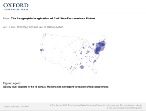
Wilkens, The Geographic Imagination of Civil War-era American Fiction, Am Lit Hist (2013) 25 (4)
Discussion: What does text mapping help us understand? What are its limits? How does scale effect textual geographies?
Managing your own domain
Access to room sheet
NYU Web Hosting – installation, organization
Read:
World Economic Forum, Digital Citizenship, Creativity and Entrepreneurship
A Brief History of Domain of One’s Own Part 1, Part 2
“Leveling up with Domain of One’s Own”
WordPress.com vs WordPress.org
Download Filezilla (an ftp client for web development) to your laptop.
In class we will look create a wordpress.com site and publish some basic content. Then we will delve into our web hosting, learn some basics in cpanel and download an instance of WordPress.org to get you started.
A good place for you to learn about such topics on your own is lynda.com–although the lessons are not always a perfect match with what you need. You can also turn to stackoverflow.com with more technical questions.
Blog Posting 1 I would like you to try out TopoText with a text of your choice (for example, from Project Gutenberg) and write a blog post (not a page) in which you document the experience, what you learned, what worked and didn’t. What did you learn about the text you chose? What did you learn about the way a computer carries out tasks? Please include screenshots and embedded links that reference and situate your discussion. Your post should be about 300 words. I will give you a chance to revise it.
Hints:
- You will want to consult the TopoText documentation here. Feel free to make comments in the doc if some part of it is not clear.
- Make sure your text is in .txt format (use your text editor). TopoText takes some time if the text is very long. Consider using a “chunk” of text where geography is particularly important to you.
- You will want to learn how to “add media” for screenshots and insert links in WordPress.
- If you wish to cite any of the readings, use the “blockquote” function.
- Be careful of linking to e-books, if your reader is not from NYU, there will be an error.
- If you choose to import the cleaned data from TopoText into Carto, you will want to learn to learn how to embed a map in a WordPress post. When you are in map view, you can click on the “public” button and then copy past the code from “embed it” at right. This is called an “iframe.”
- Copy your data into a NYU Drive Google Sheet and share the link in your posting (view only).
Week 4 – 7 (Tu 14 Feb)
Guest speaker: Amel Chabbi (Building Conservator
Historical Environment Department, TCA Abu Dhabi) will speak to us on spatial documentation of historical buildings in Abu Dhabi.
Hacking two NYUAD digital projects: Hands-on practice with Geoparsing and Web Mapping for Global Shakespeare and Akkasah.
Two large scale research projects at NYUAD are the Global Shakespeare project and Akkasah. We are going to take what we have learned so far about structured data, spatial data formats and web mapping to make a map of the both NYUAD’s recent acquisitions of global editions of Shakespeare and the photography archives of Akkasah. Then, you will learn how to make a web map similar to this one.
We will divide up the mapping project of the two projects into equal segments. The data from Global Shakespeare can be found here, and that of Akkasah here. Here is a doc with resources about Turkish photography.
Be sure you have downloaded Filezilla (an ftp client for web development) to your laptop.
Blog Posting 2 I would like you to take the assignment that we began in class and continue working on the data collection. For the Istanbul map, try to locate 5-10 places. For the Shakespeare map, location 10-15 cities of publication. In both cases put your initials in the far left column marked “data collector.” Your second blog should be about the data you and your colleagues curated and geoparsed about about Akkasah and the Global Shakespeare acquisitions. Which one was more difficult? What kinds of research did you have to do for both? What can you say about the precision/uncertainty of the data? Did making a map of the data help you understand something new about it? If so, what? What other data do you wish you had to augment the map? What other columns of metadata would you add if you could? Did you “see and think differently, more broadly, and maybe more fairly”? (Joyeux-Prunel)