Introduction
This page provides the volume estimation of 2021 residential parcels in NYC and the induced the vehicle-kilometer-travelled (VKT) by using continuous approximation (CA) methods. For the data generation methodology, please refer to this paper.
Dataset
The whole dataset can be found in the Zenodo page.
The dataset includes:
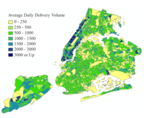
“2021 Residential Parcel Volume and Stops.zip”: Residential parcel volume and stops information of UPS, FedEx, USPS, and Amazon in 2021

Fig 1. 2021 NYC residential parcel volume by census tract
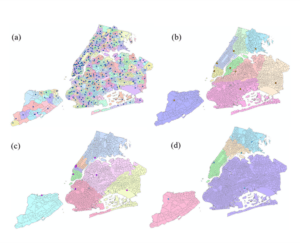
“Service Zone.zip”: facility locations represented by OSM node ID and their corresponding service areas defined by census tracts. The facility locations were obtained in July, 2022. New facilities opened after that time and the new service areas are not captured.

Fig 2. Facility locations (dots) and corresponding service areas (shaded areas) of (a) USPS (b) UPS (c) FedEx (d) Amazon
“myGraph.pickle”: pickle file storing the NYC OSM network graph. The download time is July 2022.
“Shapfile.zip”: Shapefiles containing different geographic features of NYC, which includes 2020 NYC census tracts, 2020 NYC NTAs, 2022 LION network, and the estimated parcel volume in each census tracts.
“Centroid_OSM.zip”: Shapefile storing the centroid of NYC census tracts represented by OSM nodes.
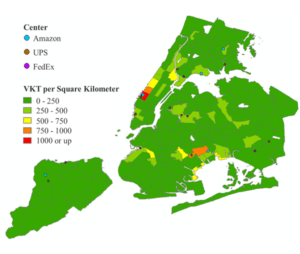
“NTA_dist.zip”: VKT result in the NTAs.

Fig 3. VKT density by NTA