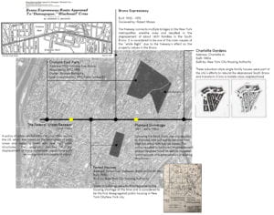
Unlike neighborhoods in Manhattan, almost every planning policy conceived by the City throughout the past century was realized in South Bronx, regardless of the community’s disapproval. From the “urban renewal” to “planned shrinkage”, the city implemented plans that greatly affected the Neighborhood. For this assignment, I created a timeline of important City projects and policies that played an important role in shaping the neighborhood the way it is today.

Photo References:
Bronx Expressway: CHARLES G. BENNETT. New York Times (1923-Current file); New York, N.Y. [New York, N.Y]15 May 1953: 1.
Forest Houses: New York City Housing Authority. Transportation facilities: Public and Institutional Buildings, etc. Project NYS Forest Houses. (created on 2018-04-23 by Matthew Martinez , NYU Gallatin; Instructed by Rebecca Amato. Updated on 2018-05-14 by Matt Martinez , NYU Gallatin; Instructed by Rebecca Amato. ) << https://www.theclio.com/web/entry?id=59210 >>
Charlotte Gardens: Startsandfits.com. (2018). Starts and Fits. [online] Available at: http://www.startsandfits.com/2006/04/bronxs-green-housing-boom.html [Accessed 1 Jul. 2018].

Love it! This mirrors my own arguments about the symbiotic relationship between the evolution of professionalized city planning and Manhattan’s Lower East Side. Every planning idea the city or the nation has is tested out in these areas, often to great failure. So what is similar about the South Bronx and the Lower East Side? I think there are a few things: entrenched poverty, building abandonment, decreased land values, and a multi-ethnic population. I’m sure there’s more! What does this say about the relationship of urban planning to neighborhoods and does it help you to think about planning differently?