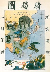
If you finished your high school education in China, you must have seen this picture in your history textbook.
 It’s a map, at the first glance. But it’s not only a map. (see some background information for the map.)
It was drawn by a patriotic aircraft designer, Xie Zuantai, who was born in late 19th century, when China was under the ruling of Qing Dynasty, and was confronting multiple crisis from western world.
In addition to indicating geography, the map was also a caricature. Glittered with greed, various threatening politic powers cast their eyes on different parts of China, expressing their intention of colony.
The giant bear in the map, occupying the three eastern provinces and running amok, is used as a metaphor for the Russian Empire. A dog, occupying the Yangtze River area, metaphor Britain. A sausage, occupied Shandong, metaphor Britain; A toad, occupying Guangdong province, Guangxi Province and Yunnan Province, metaphor France; The sun rays extend to Taiwan, is a metaphor for Japan. The eagle hovering over the south represents the United States. Not only external powers are expressed, but also the corruptive and numb image of government of Qing Dynasty is shown vividly. From the map, the distribution of political powers in east Asia, the situation of China, the relationship between each other are so obvious that arouses patriotism of numerous Chinese people. As warning, this picture was published in Chinese high school history textbook.
Although this map can’t be regarded as a true map in a serious meaning, the apparent intention of Xie makes us to think about mappings, help us to understand how map produce and express a world. Xie adopted a radical method (compared to merely making maps ) to arouse his compatriots’s patriotism, to stand up, fight against invaders and inactive government. Through his logic, we can easily understand that, mappings, are ways people express their understanding to the world except for the content itself, just like what McLuhan’s understanding the media. So, maps not only describe a world, but also produce a world.
As we could see through The Map of Current Political Situation, mappings does not just depict the landscape or represent geographies or ideas. It indicates relationships. Static object-space is shifted to space-time of relationship systems, so that we could understand space even it is separated from events that happens in it, even it is remade continuously by different people. Complex sets of relationship that need to be actualized are set through visual disclosure. That’s the instrumental significance of mapping.


