Fang Wenjun (wf646)
Mapping in ancient times and modern times
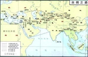
As a critical tool of understanding the local customs and practices, as well as the cultural environment, the map reflects the social conditions honestly. Early to the sixth century B.C., the ancient Babylonians began to use map recording the world they discovered. In 800 B.C., ancient Chinese began to use maps as important references when designing and building new cities. Maps became more accurate and included more details within the social development. Today, the map became much easier to access, while at the same time, became less different. Usually, limited by transportation, measuring tools, and other objective conditions, the map can only contain a particular area. However, modern technology makes everything changed. Google map users in Shanghai can easily zoom in on a specific restaurant in Italy or zoom out to view the world map. It is a great step in human history—after the maritime navigation era, people today are allowed to ‘navigate’ the whole world with the map on the phone.
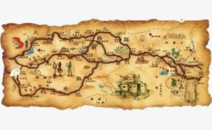
On the other hand, map designs tend to be the same. Attached below was an ancient version map of the ancient silk road (remastered version), painted by the Han dynasty’s envoy, Zhang Qian. It is easy to understand that even the map user does not know any Chinese characters since Zhang painted different icons to represent the architectures, nations, hills, and pools he met during his trip to the western regions. Zhang’s map gave people in the Han dynasty the chance to understand how the West region looks and helped trade between countries in the western region and Han. His way of painting the map is similar to the idea of ‘drift,’ a modern painting way that James Corner mentioned in his essay. Corner gave the example of Guy Debord’s ‘psycho-geographic guides,’ which was “made after Debord has walked aimlessly around the streets and alleys of the city, turing here and there wherever the fancy took him” (Corner, The Agency of Mapping). It is about the experiences and feeling you have of painting maps in such way.


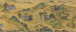
I also attached another ancient Chinese map within this blog below. We can see there are city walls which represented the cities, as well as hills that surrounded. Besides, paths to different cities are also marked clearly so we can easily find the way to the places we want to be. Compared to modern maps, it is more like paint, a piece of artwork rather than just a map. It represents not only where the city is located but represents the Chinese culture as well. By such a design, we can easily figure out the culture that the map represents. It is essential to keep the differences. The map exists in human history for a long time, and it should not be only a tool anymore.

Leave a Reply