Skip to content
On this page
- Update 1: Project Goals
- Update 2: Using Accessibility Tools
- Update 3: First Meeting with Mentor
- Update 4: GoodMaps and Waymap
- Update 5: Project and Meeting Updates
- Update 6: Information Collection
- Update 7: Reflecting on Midterm feedback
- Update 8: Creating a Plan for the Visual Guides
- Update 9: Developing the Visual Guides
- Update 10: Final Updates and Meeting with Mentor
- Update 11: Meeting with Waymap
Weekly Update 11: 5/9/23
- We had a meeting with Waymap‘s Marketing and Community Manager.
- These were the questions we prepared:
- In how many locations is it available?
- What is the process like to apply for Waymap accessibility at a venue?
- Is feet the only metric for measuring distance?
- Are you available at any museums? Do you only help in navigating from one location to another?
- What if someone needs help navigating within a room?
- Any plans for describing bodies or objects in a room?
- This is all the information we collected from the meeting:
- It is available in a limited number of locations, including Washington, DC.
- On-the-go Waymap trials in the UK and LA at Loyola Marymount University, Poland, Australia, and the UK.
- Actively exploring with public museums in the USA and UK and similar organizations to provide an audio tour experience when near a particular item in a museum.
- Troubleshooting within the app and some faq and visual maps.
- The app works well with VoiceOver and accessibility mode, and high contrast mode to help with low-vision users.
- Plan Be My Eyes, a phone help service within the app, can access the screen.
- Video and audio guides to train staff if someone needs help.
- Different from other apps like Goodmaps because they don’t focus so much on the infrastructure.
Weekly Update 10: 4/25/23
- We heard back from a representative at GoodMaps and scheduled a meeting for 5/1/2023 to ask our mentor’s and our questions and concerns regarding this technology and application.
- We had another meeting with our mentor and discussed the progress and best ways to write the visual guide descriptions.
- After threading all the visual steps together and writing relevant descriptions for each visual, we sent the document to Cheryl for review before we create the final visual guide.
- Here’s an example of what we shared with Cheryl:
Weekly Update 9: 4/18/23
- We worked on the visual guide this week and prepared the final plan to discuss with our mentor.
- We started converting the textual steps into visual steps, first in a Google document to be reviewed by our mentor.
Weekly Update 8: 4/11/23
- After talking to Prof. Amy, we reversed our approach to creating the visual guides.
- Instead of drawing out the visuals, we worked on a three-step approach where we first wrote descriptions for the guides, then divide the application process or work into multiple steps.
- After writing all the steps explaining the technology and working of these applications to sighted users, we decided that the best form of a visual guide would be real images and not illustrations.
- So, we collected all the screenshots and graphics we could find from multiple sources like websites, articles, and social media.
Weekly Update 7: 4/4/23
- Tried to contact the representatives at both, GoodMaps and Waymap.
- Found more information about the working of both the technologies and applications.
- After going through the midterm feedback, we learned that we need to clearly communicate our project goal and better distinguish between our input and output.
Weekly Update 6: 3/28/23
- Gathered all the information and completed our midterm presentation to highlight the mission and uses of GoodMaps and Waymap.
- We evaluated and talked about the missions, visions, advantages, workings, user reviews, and availability.
Weekly Update 5: 3/21/23
- We had our second meeting with our mentor.
- We discussed all the information we gathered about GoodMaps and Waymap.
- We brainstormed different forms of visual guides for sighted people: brochures, google slides, videos, and prototypes.
Weekly Update 4: 3/7/23
- Some of the tools/applications we explored:
- GoodMaps
- Waymap
- BlindSquare
- RightHear
- We picked GoodMaps and Waymap to create visual guides; they are both free, and we gathered useful information about them.
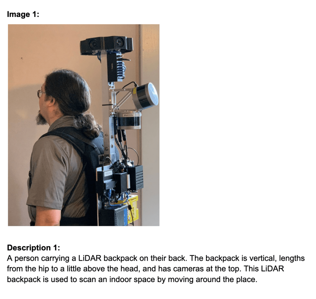
- GoodMaps is a wayfinding and navigation application that uses advanced LiDAR, machine vision, and machine learning to create a geospatial technology platform capable of enabling universal inclusive navigation throughout the indoor world.
- Waymap is another navigation application that provides free audio step-by-step directions to users, directing them within 3 feet of accuracy.
Weekly Update 3: 2/28/23
- We finally had our first meeting with our mentor, Cheryl Fogle-Hatch, and we shared our experiences with different tools. We discussed some of the readings that Prof. Amy recommended and better understood the project goal.
- After the meeting, Cheryl sent us articles and websites to learn how blind users navigate through indoor and outdoor spaces, like buildings and transit systems.
Weekly Update 2: 2/21/23
- We used different accessibilities tools like:
- VoiceOver on iOS
- Experience: We both tried to use the VoiceOver feature on our phones for one day. It was a very confusing experience because we could not figure out a lot of the settings. Carla even got locked out of her phone for a long time. One of the major issues was that it is very difficult to scroll through the screen, and we would have liked it more if, for documents or PDFs, it would automatically scroll through instead of waiting for the user to do the scrolling. Overall, this was a very frustrating experience.
- Audio Descriptions
- Experience: We both ended up watching Gilmore Girls using audio descriptions. Although it was a pretty good experience, I think it also depends on the content. If a film/series is fast-paced and doesn’t have long enough silent pauses, it would be challenging to fit the audio descriptions. Also, we noticed that some details were left out, which might not be too essential to the plot but takes away from the experience.
- Siri on iOS
- Experience: We used Siri for one day to do all our tasks on the phone. It is a great tool for sure, but there are still some troubles with different accents.
Weekly Update 1: 2/14/23 (Goals)
- Team Name:
- Maps, Apps, Oh My!
- We stuck with the original name, Maps, Apps, Oh My!, because it sounds exciting and summarizes our work and experience throughout this project. We have been learning a lot about two applications: GoodMaps and Waymap; both of them produce 2D or 3D models of a space or location in order to make navigation accessible for blind people. And ‘Oh My!’ has been our experience working with this project because we got to learn about many new technologies, and we hope when other sighted folks go through our visual guides, they learn about these applications and say, “Oh My! We should utilize them!”
- Select the student who will be the main point of contact for the group to schedule meetings and manage emails:
- Overview of team member responsibilities:
- Abhishek Rana: Gathering information and developing a visual guide for Goodmaps.
- Carla Guzman: Gathering information and developing a visual guide for Waymap.
- Schedule for regular meetings throughout the semester:
- Every Tuesday at 4:00 p.m. ET
- Description of the project :
- The aim of this project is to develop a visual guide for sighted folks to familiarize them with these applications for the purpose of eventually helping blind visitors in accessing currently inaccessible spaces.
- What tools/expertise will you leverage to complete the project?
- What does your team already have a good understanding of?
- Research and creating visuals
- What additional tools/expertise will you need to complete the project?
- Learning how to correctly describe images or write relevant alt text
- What is your timeline?
- Explore different types of accessibility tools.
- Read relevant papers and articles.
- Meet with our mentor to understand the project’s end goal.
- Research about GoodMaps and Waymap.
- Prepare the midterm presentation.
- Create/develop the visual guides.
- Get feedback on the guide from our mentor.