Wayfinding: What I have learnt from my peers

As I write my final blog post for the semester, it is hard to believe that we are coming to the end of the fourteen weeks of Wayfinding. At this realization, I am met with a range of emotions: sadness, excitement, gratefulness, and motivation, to list a few. But, I suppose the notion of wayfinding does not end as these fourteen weeks do. Wayfinding is everywhere; from along the Highline to on the busy city roads to inside metro stations and shopping malls, to even digital means. This class helped me recognize the weight wayfinding design carries. In addition to the ever-presence of wayfinding, there are some takeaways from this class that I will take with me beyond this classroom. I want to share my most important one: what I learned from my peers. 

Before I begin enumerating some snippets of what my peers have taught me, I want to give a little tribute to Professor Goffredo. From the very first virtual class, Professor Goffredo has been imparting little words of wisdom here and there. ‘Life Lessons with Professor Goffredo,” if you will. Yes, I have coined the term now. Anyway, one of the first “Life Lessons” Professor Goffredo gave to the class is one that has stuck with me. He said something along the lines of that people, in general, invest so much money, so much time, and so many resources into trying to bring together a diverse group of people; diverse in terms of financial background, race, ethnicity, religion, gender, political beliefs, etc. All we have to do is go to the D2 dining hall. Our wayfinding class has proven to be an obvious example of this. 

It was from Ishmal that I realized the importance of universality in pictogram design. She highlighted to there is a balance needed between consistency for clarity and brand identity in terms of pictograms through her analysis of the unique set of pictograms designed for Expo 2020 Dubai. Perhaps pictograms are not the place for companies to be reinventing the wheel as they can leave users even more confused. On a side note, she also taught me how getting on the wrong bus in Florence can push you to discover a whole new part of the city – and put you even further away from your intended destination. 

It was from Jennifer that I truly comprehended the notion of affordance and nudges in wayfinding design. Through sharing her experience at Umm Al Emarat Park, she highlighted the discrepancy between what the design of the environment allows the user to do and what the user is actually permitted to do (in this case, according to the security guard). But if I am able to stand on the slabs of concrete on the water, they probably want me to, right? Jennifer also did an in-depth analysis of Olympic pictograms. This blog post of hers was super useful for me to generate ideas for my own impossible pictogram – so thank you, Jennifer! 

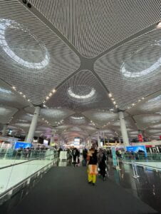
It was from Laura and her experience navigating through the Istanbul Airport during a layover that brought valuable insight into the necessary features of airport wayfinding systems. Big, clear, and visible signage systems, useful and conventional pictograms, an intuitive layout, and accessible pathways are all important components of such a system. Especially with so many people traveling in and out of this airport from all around the world, it is important that the airport functions seamlessly to avoid frustrating, and costly, complications. 

It was from Yeji that I was compelled to make more of a conscious effort to be more attentive to my surroundings, and from a multi-faceted perspective. In terms of design, this finding has helped me make sure I keep the user experience in mind – in whatever form that may be. For instance, designing for accessibility, intuitiveness, comfort, ease, etc. Moreover, this attentiveness has also prompted me to take a step back more often to pause and just be more attentive to the world around me. Just as she did with her amazing drawings!

It was through Hasin that I learned the power of tactile brainstorming. Perhaps this is another one of Professor Goffredo’s life lessons. Hasin covered entire whiteboards with sketches, drawings, and brainstorms of ideas for his impossible pictogram. When I felt stuck and felt like I had run out of ideas, I went to him for help and the advice he gave me was to keep sketching…in a tactile form (on paper, the whiteboard, etc). It was eye-opening to observe the process of how an idea can evolve and develop as you continue to draw it and work with it in different ways.

It was through Zunair that I was able to broaden my definition of wayfinding to include online wayfinding as well as broaden my definition of online wayfinding itself. I was under the impression that online wayfinding entailed applications such as Google Maps or Waze. After reading Zunair’s blog, however, I realized that navigating through all kinds of applications and websites are also forms of digital wayfinding. This is especially important with the rapid development and growth of technology, even more so in a pandemic/post-pandemic society. 

It was through Ulan that I have become less naive to the effect that advertisements have on me. I know to be wary of tactics employed heavily by the advertisement industry such as the attractiveness bias or the familiarity which help in persuading consumers to purchase the product/service being advertised. It is quite scary to know that through these methods, industries as such have the power to shape societal norms and behaviors and subtly mold the mindsets of consumers. 

It was through Abdulrahman that I was able to ask for help more comfortably. Abdulrahman and I sat next to each other throughout the semester. Thus, he was naturally the first person I would turn to ask for feedback on an idea, to ask for help in navigating software like Photoshop or Illustrator, to test out my ‘Cheat Sheet,’ etc. I will admit that all this required me to change my mindset and push myself outside my comfort zone. I had to realize and internalize the notion that asking for help is not a sign of weakness or incompetence, but a request for more information and knowledge. 

And that is just the tip of the iceberg. I can not list every single thing I have learned from each of my peers, but I hope this provided a little insight. I have learned so much from those around me and have grown tremendously because of it. My knowledge of wayfinding design has grown, my ability to effectively communicate visually and verbally has expanded, and my capacity to ask questions and for help has developed by many, many folds. All in all, I have been prompted to reflect on my time at NYUAD thus far and grown to appreciate the interactions I have had with the diverse student body to a whole new level. The fact that such diversity is so readily available to us is incredible and this class has allowed me to be grateful for the space I hold here – and what I can do with it.
Expo 2020 Wayfinding Design

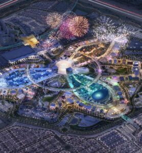
Considering the magnificent area of 1083 acres, with pavilions from 190 countries and further 20 organizational and special pavilions, on a site expecting to host 25 million visitors, designing a self-explanatory wayfinding system could not be an easy task. Considerations had to be made for the diversity of people who would be attending one of the largest global events, ranking alongside Olympics and the FIFA World Cup, as well as simultaneously exhibit the rich and unique culture and architecture of the United Arab Emirates. I believe that it was a consequence of these considerations that the wayfinding system had to be completely redesigned after 2015. 

Expo 2020 site

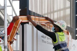
London Studio Spaceagency was appointed to develop the wayfinding and signage system for the international event including plazas, concourses, entrances, parks, car parks and internal transports, with the help of local craftspeople, over a span of 8 years. The aim of the design was to “weave the cultural heritage” into it and avoid a generic feel. 

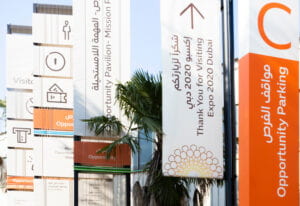
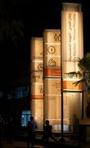
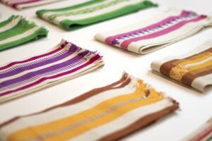
The signage design was inspired by a UNESCO-protected Emirati weaving technique called Al Sadu, which is a Bedouin tradition that is practiced in rural communities of the UAE. Each area has its own colors based on local pigments as well as regional symbols that can be woven into patterns. Similarly, each of the themes of the expo were given their color-coded identity and a different pattern using Sadu which split the expo into 5 smaller zones in order to be easily visualized from great distances and therefore provide an easier means of navigation between the different zones and car parks.


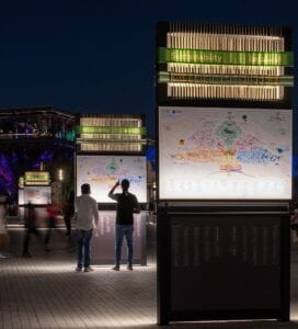
The map of the expo was also color coded correspondingly, and copies of it were placed around the site very frequently in order to familiarize the people with the theme behind each color, achieving a good balance between simplicity and redundancy. A noticeable landmark was also placed in each zone which fulfilled all the 4 conditions that a distinguishable landmark should: visible, conspicuous, easy to talk about and immutable.

Though the overall area seems easy to navigate and understand through the color-coded identities, the design and signages at particular instances, or sometimes the lack thereof, made me wonder about the effectiveness of the wayfinding system and whether the priority of the designers behind the infrastructure was the promotion of culture or ease of navigation.

As my friends and I entered the Expo, we were already lost at the entrance because we were unable to find the ticket booth. After searching on the signages for any indication of the booth, we had to eventually resort to asking an officer for the directions, getting an answer that the booth was situated after going straight, right, straight, left and then right, confusing us even further. There were also no signages in the way except for when we could already see the booth from a distance. The purpose of placing a ticket booth so complicatedly far from the entrance was something we were unable to decode.

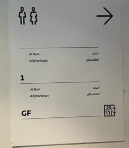
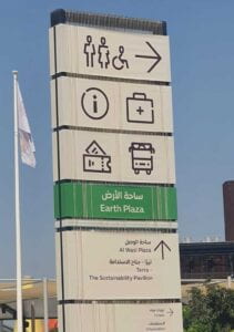
As we walked along further amidst the pavilions, we noticed that not only was there a lack of signages, some of them were also designed and placed inaccurately. An example of this was a sign which inaccurately informed us that the first and the ground floor in fact had the same spaces; Al Baik and Afghanistan were on the ground floor as well as on the first floor.

As shown in the picture below, another example was a sign board which held multiple pictograms, however without any indication of where they point towards. If the information center was on the right, under the signage or coming up ahead, was not clear at all.

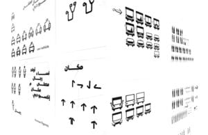
The most interesting aspect of the wayfinding system at Expo, however, was undoubtedly the unique design and depiction of the pictograms. The pictograms were created by the Spaceagency in collaboration with a Dubai-based design studio Tinkah. A calligraphic design was chosen to blend recognized pictograms with Arabic letterforms. 

The symbols were then used throughout the signage scheme at the Expo 2020 site. 

However, of how many pictograms from the picture above, can you state the meaning with utmost assurity?

Pictograms are universal pictorial signs that signify what they depict. They should be highly motivated so the intended viewer is immediately able to understand. Pictograms should also be conventionalized so they are standardized, well published and used consistently to teach the intended user its meaning. If one of the two conditions of motivation or convention fail, the other condition becomes important. If the user is not able to understand the pictogram, they should be able to remember it. If they cannot remember seeing the pictogram before, it is good to understand what it means by simply seeing it.  

However, the pictograms that were carefully crafted for Expo 2020 did not seem to meet either motivation or convention. For example, a design for a first aid kit is usually a cross in Western countries while a crescent in the UAE. To avoid conflicts of understanding, the design team eventually used a stethoscope.

As a stethoscope is not a conventionally used symbol for medical aid, the user is not immediately able to understand if that’s the purpose it serves. In an emergency situation, it is not ideal for the user to be conflicted about the meaning of the symbol instead of acting with urgency to cater to the emergency at hand. Instead a medical kit with a cross and crescent, such that is used in the Gulf, could have perhaps been designed which would indicate in clarity for both the audience its intended meaning.

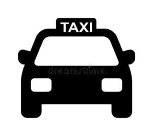
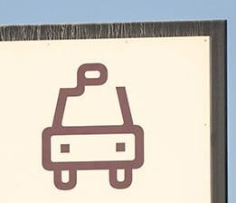
Similarly the universal pictogram for a taxi is highly motivated as the word taxi is clearly stated over it, however the one used at the Expo happened to confuse us regarding its meaning, we almost thought it was a chairlift!


On the other hand, the bus pictogram for the bus used at the Expo site did resemble the universal pictogram, however, it in fact looked similar to the pictogram of a man to indicate the direction of the toilets at the Expo, and hence instead the bus pictogram as a whole resembled a man standing behind a table, so perhaps a giveaway stand or an information desk.


Though the pictorial representation of signs in such a manner was intended to showcase Emirati culture, I personally would not have recognized the motivation behind these symbols was to represent Arabic calligraphy unless I had not read about it. Therefore, such contradictions in the design only complicated my user experience at the Expo instead of creating user enlightenment and admiration for the UAE culture.

As was done through the technique of Sadu and woven ropes behind the signages, in my opinion there was plenty of room to represent the local traditions; adding Arabic letterforms to the pictograms did not only not add much value to the depiction of Emirati culture but also failed to help maximize the purpose of the pictograms and hence could have perhaps been designed in an alternate way, if culture representation was a must.

In conclusion, the overall signage at the Expo including maps, the visibility of directions, font type, hierarchy of information on the signages were all some excellent examples of wayfinding design however improvements could have definitely been made to fine tune the user experience instead of prioritizing the ‘visual feel’ over the purpose of wayfinding.

Wayfinding and the Istanbul Airport

Istanbul Airport, also known as the World’s Largest Airport, is a landmark for international transportation. With more than 40 million passengers and a capacity to handle 90 million per year, this airport was awarded “The Most Efficient Airport in the European Union” by global leading aviation researchers at Air Transport Research Association in 2021. This gives us a peek into the impact this airport has in global commerce and tourism. And having been there at least 3 times, I can attest to the “strong infrastructure, efficient operation, superior technology, and premium travel experience” that it offers. However, I would say its most remarkable yet unnoticed characteristic is its wayfinding design. 

When coming to NYUAD for the first time, I had a layover of 14 hours in Istanbul Airport, exposed to making thousands of decisions based on zero knowledge of the space I found myself in. As a first timer traveling to the other side of the world, I didn’t feel lost during my layover in Istanbul Airport. Of course, I didn’t know back then that this was connected to the good wayfinding this airport has. However, I did feel confused from time to time given the large size of said airport, so I will be going through the good examples we can apply someplace else and the things that can be improved. 

One thing that I believe this airport did right is find a good balance between simplicity and redundancy in their signage and gates. They did a great job of playing with letters and numbers to name the different gates so as to avoid confusion and eliminate the perception that the airport is too big. For example, they could have had C50, but instead they chose small numbers and different letters. The quote in their website is “Do not be afraid to ever miss your flight with us” and it is actually true. They have big screens very close to each other and signage with the right distance between them to make sure no one misses their flight information. The balance of information and medium is perfect and very convenient for travelers from all parts of the world.

Adding to the positive design you can find at the Istanbul Airport, you have accessible pathways! As you navigate one of the biggest airports yet to exist, there are lifts where there are stairs. There are also a lot of electrical path rushers to make it in time for those who can’t run. Moreover, there are various cars to put your heavy bags on for which you can get a reimbursement after you use them almost everywhere in the airport. This is one of the highlights of the airport, and I wish there were more airports with these options. 

In contrast, one thing I struggled with was finding the exchanging places late at night. It was an emergency, really, it was my last chance to try the Turkish ice cream, and I only had big bills for which they didn’t have change. I spent 40 minutes walking all around the airport, asking people around, and I believe they didn’t have any exchange servers sign, or at least not clear, visible ones. I risked losing my flight that night, all because there were no signs about the exchange servers’ locations. Now, on a more serious note, this is very relevant, especially in such an international hub of travelers with people coming from LITERALLY all parts of the world with all different currencies. Therefore, one thing this airport lacks is effective, clear signage of money exchange servers, which would save a lot of people time and struggles. 

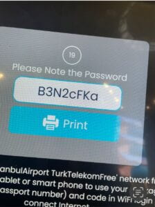
Similarly, there are no signs for the wifi connection places, which needless to say, are very important in Airports. But why can’t people just connect to the wifi from where they are? In Istanbul Airport, you only get one hour of wifi per passport. This means, you need to find a wifi spot, scan your passport, and connect to the wifi. If you’ve been traveling for 12 hours for the first time and you need to let your family know that you made it okay (in my case), then finding these spots should be a priority in signage. Moreover, even if you’re in an airport, you should have the right to know where you are at and do research on questions that might pop up, like where is your airlines’ section or what are the best places to eat.

The wayfinding design at Istanbul Airport is mostly on point, at least the intention: big, visible signage everywhere; clear names for the gates; intuitive signage for bathrooms, food, prayer rooms, and other attractions; and accessible pathways. With this in mind, there are some details to work on, like the visibility of money exchange places and wifi connectivity spots. From my personal experience, I can attest that navigating this HUGE airport is mostly very intuitive and smooth. Overall, there are so many things to replicate worldwide, but some things to be learned from other places and be applied. 

SOURCES: