A well-functioning, reliable, and efficient public transportation system is a valuable addition to a city. Services such as metros, trains, public buses, monorails & trams, etc. can provide various benefits to a city and its occupants. Some cities have almost seamless public transportation systems. Take for instance New York City, Dubai, or Hong Kong – the public transport systems have become cultural identity factors of the city and their efficiency has decreased the need for people to invest in and use private transportation, ultimately reducing road congestion, pollution, and cost. Few cities have little to no public transportation infrastructure.
Most cities fall somewhere in the middle of these extremes. For example, my home city of Manila, Philippines has a metro system and public bus system. However, they are overcrowded, dirty, and ultimately not used by most of the city’s population. Most people, therefore, have private vehicles (and multiple of them!), leading to so much congestion and traffic that Manila has consistently been ranked by the TomTom Traffic Index (Abu Dhabi Traffic Report: TomTom Traffic Index) as one of the top five cities for worst vehicle congestion. Another example of a city that lies somewhere in this middle ground is New Delhi, India where there is a well-functioning metro line, and a decent public bus system. However, these systems are just not equipt to handle the 30 million-odd occupants of the city. All this to say that there are so many aspects that go into what makes a public transport system efficient – and that these aspects vary from city to city.
The most cost-effective method to head downtown from campus to downtown Abu Dhabi is the public bus. The 170 line takes you directly from campus to Hamdan Street and beyond. I did not see many flaws with the system in place. It was clean, efficient, and cost-effective. Until this past month. I took the public bus downtown a couple of weeks ago and this time, I found myself paying attention to the aspects of good, and bad, wayfinding design in this space.

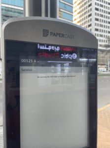
Firstly, I noticed that as you approached the bus stop, there was a screen to tell inform you about the buses that are due and the time they depart. I thought this was a great idea – it informs the viewer of the bus schedule and allows the user to plan accordingly. I know that there is an app that displays this information as well, but it is hard to use and many tourists may not have it or may not have cellular services to access it. However, I found that the screen was not working properly and all that was displayed was text stating that there were “No services for this stop to display at the moment!” The entire system was down – all throughout the city. Well, how am I supposed to find the timings for my bus then? Am I supposed to just wait here indefinitely till the bus I need to take shows up?

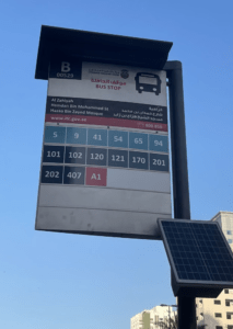
I also noticed that the bus stop mentions on its signage the bus numbers that depart and arrive at that stop. But, what do these numbers mean? What route exactly does each bus take? Where is the nearest bus stop to my desired destination? Do I have to change bus lines? Which stop do I change it? There are 3,603 of them (DARB – Bus Times, Bus Routes, and Updates)! Perhaps a map similar to that of a metro map could be added with the bus stops at each station. A conscious and straightforward map that informs the user where it is they are going and which bus to take to get there. Without this, for people not familiar with Abu Dhabi, it seems quite daunting to navigate all these numbers and try to figure out how to find your way from point A to point B. In addition, the numbering system is not consistent. While DARB only has 99 bus routes in Dubai and Abu Dhabi, this sign suggests there are many more than that. Some routes are even labeled with a number and a letter (eg. A1). As mentioned in Per Mollerup’s book Wayshowing > Wayfinding: Basic and Interactive, Mollerup mentions that the two basic requirements for a good numbering system are logic and consistency. Perhaps all the routes should be labeled with numbers only or all with a letter and number – what I am trying to get at is that perhaps the labels should be consistent and use the same logic. Or perhaps these buses are different than the rest, but there is no indication as to why. Improving clarity in this would allow users to use other wayfinding strategies, such as inference, to navigate the system.

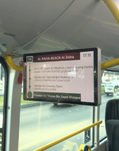
Additionally, in terms of signage, the inside of the bus is equipped with multiple screens displaying the next stops on the bus route, the time, and additional safety information. This information is displayed in both English and in Arabic, making it more accessible for both the local and expatriate community of Abu Dhabi, as well as tourists visiting the city. I have observed that this is quite a new addition to the public bus system but it is one that has been extremely helpful. However, perhaps there could also be an announcement as the bus is approaching stations for those with visual impairments or those just simply not paying full attention to the bus (sleeping, talking, etc.). This plays to this idea of simplicity versus redundancy, which is also mentioned in Per Mollerup’s book Wayshowing > Wayfinding: Basic and Interactive. Although the addition of a loudspeaker to also verbally communicate this information may be redundant, this redundancy may clarify the message and information for some passengers.

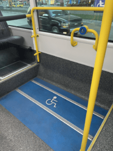
A particular aspect of the public bus system that I began to pay more attention to after taking this class is accessibility. From what I have noticed, all of the public buses have a ramp that can be employed for someone with a disability or in a wheelchair to be able to access. The buses also have an area to store a wheelchair or for people in wheelchairs to sit and hold the rail while the bus is moving. I found that in terms of accessibility, the Abu Dhabi public bus system aims to make this form of public transportation accessible to everyone which is really important. It is a public system after all.
As the population of Abu Dhabi and tourism in the region continue to increase, an efficient and easy-to-navigate public transportation system is vital. Perhaps a few changes and additions in signage, logic, and redundancy could improve the existing system and allow users to use additional wayfinding methods such as inferencing or map reading to better navigate through the system and the city. In any case, it is apparent that the designers of this system and the Abu Dhabi government have put significant time, effort, and monetary support into developing the existing public bus system in Abu Dhabi. Even more so, these bodies seem open to improving the existing system as they have been making adjustments even recently – with the addition of new technologies and accessibility measures. Maybe in the next couple of years, we may see fewer cars on Abu Dhabi streets and a whole lot more buses – or even a metro?
Sources:
“Abu Dhabi Traffic Report: TomTom Traffic Index.” TomTom Traffic Index, https://www.tomtom.com/en_gb/traffic-index/abu-dhabi-traffic/.
“DARB – Bus Times, Bus Routes and Updates.” Moovit, DARB, https://moovitapp.com/index/en/public_transit-lines-Dubai_Abu_Dhabi-3824-864210#:~:text=DARB%20is%20a%20public%20transportation,Dhabi%20with%203603%20Bus%20stops.
Mollerup, Per. Wayshowing> Wayfinding: Basic and Interactive. BIS, 2013.